
For a rail journey, a venue reached without transfers can be easier to visit than one closer in a straight line. Planning two stops on the same line, for example, is easier when stations and arcades appear together than when reading a distance-sorted list.
Musecat Beta connects the metropolitan rhythm-game arcade rail map for this kind of discovery. It adds a way to choose candidates along the rail network alongside individual venue addresses.
Finding arcades through the rail network
Distance sorting suits searches around a current location. Comparing stops along one line or transfer options requires separately matching stations with venues. Planning several visits repeats that work.
The metropolitan rhythm-game arcade map is a separate project describing venues near regional rail and their operating status. It helps select station areas to explore, while Musecat documents provide detailed venue information.
Working with an external map author
The map is also our first system built with a contributor outside the Musecat development team as the client. Here, the client makes the map and needs a way to present and distribute that output. This differs from deciding for myself which screen to build.
The author supplies stations, venues and symbols already arranged. A readable viewer and downloadable editions fit that need better than another web editing tool. Themed presentation, zoom, legends and edition descriptions support that use.
The author updates map content and the service publishes supplied editions. Checking that web assets and downloadable files match when a new edition arrives is part of this collaboration.
Listing criteria and map symbols
Putting every detail into one map would make names and lines difficult to read. Listings use distance from stations and rhythm-game availability. Naming priorities and multiple-venue marks handle several places near one station, while symbols distinguish supported game networks.
The network is simplified around listed venues, making the legend important. The interface explains line colors and symbols, with separate guidance for listing criteria. Readers can check both the map's inclusion rules and each venue's detailed information.
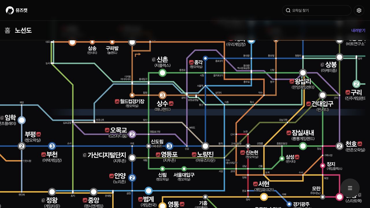
Reproduced from the 2023-12-25 Beta code using the metropolitan map bundled at the time. Original Korean screen; Beta supported Korean only.
Web maps and downloadable editions
The web view selects an SVG for the light or dark theme. SVG is a vector format suited to keeping lines and text clear when enlarged. Zooming, panning and a larger mobile starting scale help readers inspect an area, with the legend in the map's menu.
Downloads read a separate edition list containing version names, publication dates, descriptions, previews and links. Creation time distinguishes the latest edition. Display SVGs and downloadable files follow different update paths, so operators must publish matching versions.
Visit planning and edition updates
Readers can compare candidates along rail lines, download the map for preparation or print it for a venue. A contact route for custom print editions also supports using the same work beyond the website.
The map remains an edited publication that changes with venues and lines. It supplies neither live train information nor route guidance, and its operating information may differ on the visit date. Readers should check current venue details, while authors and operators keep produced and published editions aligned.